![](/images/other/stat-length.png)
![Trail On foot Borgo San Lorenzo - Sentiero Ceroni Pier Giorgio, Donati Pierino - Photo](https://media.geolcdn.com/t/1900/400/484a73ee-a64f-4bc5-b576-0dd44087b5af.jpeg&format=pjpeg&maxdim=2)
Sentiero Ceroni Pier Giorgio, Donati Pierino
SityTrail - itinéraires balisés pédestres
Tous les sentiers balisés d’Europe GUIDE+
![Length](/images/other/stat-length.png)
Length
3.8 km
![Max alt](https://static1.geolcdn.com/siteimages/upload/files/1508320355ic_sort_altitude_max_24dp.png)
Max alt
988 m
![Uphill gradient](https://static1.geolcdn.com/siteimages/upload/files/1508320355ic_sort_den_pos_24dp.png)
Uphill gradient
243 m
![Km-Effort](/images/other/stat-length.png)
Km-Effort
6.9 km
![Min alt](https://static1.geolcdn.com/siteimages/upload/files/1508320355ic_sort_altitude_min_24dp.png)
Min alt
755 m
![Downhill gradient](https://static1.geolcdn.com/siteimages/upload/files/1508320355ic_sort_den_neg_24dp.png)
Downhill gradient
174 m
![Boucle](https://static1.geolcdn.com/siteimages/upload/files/16400158638029165_repeat_loop_refresh_sync_direction_icon.png)
Boucle
No
Signpost
Creation date :
2022-02-15 17:22:58.684
Updated on :
2022-03-01 20:44:46.611
![On foot](https://static1.geolcdn.com/sitytour/trail-icons/100.png)
1h33
Difficulty : Easy
![Scan this QR Code to open this trail in the SityTrail application](https://capi.geolives.com/qq0zvz2zws4bq2lad0pu/sitytour/trails/3122502/qr.png?size=200)
FREE GPS app for hiking
About
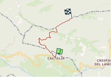
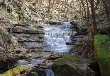
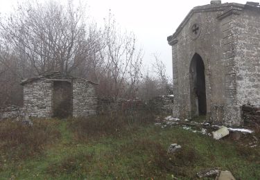
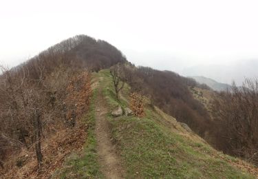
Trail On foot of 3.8 km to be discovered at Tuscany, Metropolitan City of Florence, Borgo San Lorenzo. This trail is proposed by SityTrail - itinéraires balisés pédestres.
Description
Trail created by CAI Faenza.
Relation maintened by Gabriele Sani (CAI-FA)
Symbol: 551A on white red flag
Website: http://www.caifaenza.it
Positioning
Country:
Italy
Region :
Tuscany
Department/Province :
Metropolitan City of Florence
Municipality :
Borgo San Lorenzo
Location:
Unknown
Start:(Dec)
Start:(UTM)
701708 ; 4879175 (32T) N.
Comments
Trails nearby
![Trail On foot Borgo San Lorenzo - Sorgenti di Firenze Trekking – Anello Principale: Tappa 2 - Photo](https://media.geolcdn.com/t/375/260/e9201934-1504-4de1-90ca-58ff0ff3313b.jpeg&format=jpg&maxdim=2)
![On foot On foot](https://static1.geolcdn.com/sitytour/trail-icons/100.png)
Sorgenti di Firenze Trekking – Anello Principale: Tappa 2
On foot
Difficult
Borgo San Lorenzo,
Tuscany,
Metropolitan City of Florence,
Italy
![](/images/other/stat-length.png)
22 km | 35 km-effort
8h 0min
![](https://static1.geolcdn.com/siteimages/upload/files/16400158638029165_repeat_loop_refresh_sync_direction_icon.png)
No
![Trail On foot Borgo San Lorenzo - IT-535A - Photo](https://media.geolcdn.com/t/375/260/2f7a669c-1532-41d2-a9f6-7a178937c729.jpeg&format=jpg&maxdim=2)
![On foot On foot](https://static1.geolcdn.com/sitytour/trail-icons/100.png)
IT-535A
On foot
Easy
Borgo San Lorenzo,
Tuscany,
Metropolitan City of Florence,
Italy
![](/images/other/stat-length.png)
3.3 km | 7.7 km-effort
1h 45min
![](https://static1.geolcdn.com/siteimages/upload/files/16400158638029165_repeat_loop_refresh_sync_direction_icon.png)
No
![Trail On foot Palazzuolo sul Senio - IT-581 - Photo](https://media.geolcdn.com/t/375/260/71356f92-0b1b-4feb-9dcf-edda0968194b.jpeg&format=jpg&maxdim=2)
![On foot On foot](https://static1.geolcdn.com/sitytour/trail-icons/100.png)
IT-581
On foot
Easy
Palazzuolo sul Senio,
Tuscany,
Metropolitan City of Florence,
Italy
![](/images/other/stat-length.png)
3.3 km | 5.5 km-effort
1h 15min
![](https://static1.geolcdn.com/siteimages/upload/files/16400158638029165_repeat_loop_refresh_sync_direction_icon.png)
No
![Trail On foot Borgo San Lorenzo - (SI L08) Passo della Colla di Casaglia - Passo del Giogo di Scarperia - Photo](https://media.geolcdn.com/t/375/260/888c2f52-942d-4222-a2ac-aafbfb0868d8.jpeg&format=jpg&maxdim=2)
![On foot On foot](https://static1.geolcdn.com/sitytour/trail-icons/100.png)
(SI L08) Passo della Colla di Casaglia - Passo del Giogo di Scarperia
On foot
Easy
Borgo San Lorenzo,
Tuscany,
Metropolitan City of Florence,
Italy
![](/images/other/stat-length.png)
11.6 km | 16.2 km-effort
3h 41min
![](https://static1.geolcdn.com/siteimages/upload/files/16400158638029165_repeat_loop_refresh_sync_direction_icon.png)
No
![Trail On foot Palazzuolo sul Senio - IT-741 - Photo](https://media.geolcdn.com/t/375/260/8ec91149-73e4-4168-9bc3-821e058f9a3b.jpeg&format=jpg&maxdim=2)
![On foot On foot](https://static1.geolcdn.com/sitytour/trail-icons/100.png)
IT-741
On foot
Easy
Palazzuolo sul Senio,
Tuscany,
Metropolitan City of Florence,
Italy
![](/images/other/stat-length.png)
7.7 km | 13.6 km-effort
3h 5min
![](https://static1.geolcdn.com/siteimages/upload/files/16400158638029165_repeat_loop_refresh_sync_direction_icon.png)
Yes
![Trail On foot Borgo San Lorenzo - IT-34 - Photo](https://media.geolcdn.com/t/375/260/5dc2f472-a2d0-4211-86b0-20d06b5f739a.jpeg&format=jpg&maxdim=2)
![On foot On foot](https://static1.geolcdn.com/sitytour/trail-icons/100.png)
IT-34
On foot
Easy
Borgo San Lorenzo,
Tuscany,
Metropolitan City of Florence,
Italy
![](/images/other/stat-length.png)
7.1 km | 10.9 km-effort
2h 28min
![](https://static1.geolcdn.com/siteimages/upload/files/16400158638029165_repeat_loop_refresh_sync_direction_icon.png)
No
![Trail On foot Palazzuolo sul Senio - Giro dell'Altello - Photo](https://media.geolcdn.com/t/375/260/3930022e-d1a8-4a47-8f6c-bcce356ae891.jpeg&format=jpg&maxdim=2)
![On foot On foot](https://static1.geolcdn.com/sitytour/trail-icons/100.png)
Giro dell'Altello
On foot
Easy
Palazzuolo sul Senio,
Tuscany,
Metropolitan City of Florence,
Italy
![](/images/other/stat-length.png)
8.4 km | 13.8 km-effort
3h 7min
![](https://static1.geolcdn.com/siteimages/upload/files/16400158638029165_repeat_loop_refresh_sync_direction_icon.png)
Yes
![Trail On foot Marradi - IT-551 - Photo](https://media.geolcdn.com/t/375/260/cc93723b-6516-47bb-857e-6bf8ba80532a.jpeg&format=jpg&maxdim=2)
![On foot On foot](https://static1.geolcdn.com/sitytour/trail-icons/100.png)
IT-551
On foot
Easy
Marradi,
Tuscany,
Metropolitan City of Florence,
Italy
![](/images/other/stat-length.png)
7.6 km | 14.5 km-effort
3h 18min
![](https://static1.geolcdn.com/siteimages/upload/files/16400158638029165_repeat_loop_refresh_sync_direction_icon.png)
No
![Trail On foot Marradi - IT-547 - Photo](https://media.geolcdn.com/t/375/260/1855838b-318e-47ce-b764-679b4073a983.jpeg&format=jpg&maxdim=2)
![On foot On foot](https://static1.geolcdn.com/sitytour/trail-icons/100.png)
IT-547
On foot
Easy
Marradi,
Tuscany,
Metropolitan City of Florence,
Italy
![](/images/other/stat-length.png)
4.2 km | 9.7 km-effort
2h 12min
![](https://static1.geolcdn.com/siteimages/upload/files/16400158638029165_repeat_loop_refresh_sync_direction_icon.png)
No